|
|
Onomy Labs develops the GeoConnecTable
See the video
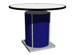
Onomy Labs, in collaboration with Churchill Navigation and TerraColor, has developed the GeoConnecTable. Based on the interface for Onomy's Twisty and Twirly Tables, the GeoConnecTable displays the entire Earth at once and allows the user to zoom in to see houses and cars.
 |
 |
 |
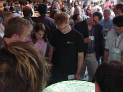
| The Geo-ConnecTable was a crowd-pleaser at Where 2.0 in San Jose, California, June 2006. | ||
Using the intuitive interface of the Twisty and Twirly Tables, the user can explore the world by tilting the table to rotate the earth. Zooming in is done by either twisting the table or spinning the top -- clockwise to zoom in and counter-clockwise to zoom out. The zoom range goes from an altitude of 250 miles down to ground level. As the camera descends, the city and street overlay information and detail increases smoothly so it appears to be a continuous zooming motion. The panning gives the impression of flying across the world.
 |
 |
 |
| The Geo-Explorer Table was a crowd-pleaser at Where 2.0 in San Jose, California, June 2006 | ||
Users can also swipe their driver's license and have the table immediately find their house. Another feature is an automatic flyby that uses topographic information to give the impression of a 3-dimensional terrain.Bruce Stewart of O'Reilly called the Geo-ConnecTable "the funnest, hands-on-demo at the fair."
For more information, please contact info@onomy.com.
More information about Churchill Navigation here.
More information about TerraColor here.
| Home | People | Products | Interactives | Research | Consulting |
| Onomy News | Directions | Email Onomy |
| 851 Hamilton Ave., Menlo Park, CA 94025 650-330-0400 |